Thursday, June 16, 2005


California Shake Map Posted by Hello

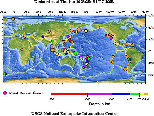
Earthquake Maps Posted by Hello

Friday, June 10, 2005

2006 King, Pierce, and Snohomish County Thomas Guides In Stock!

Thomas Bros. Maps has released the 2006 edition of King County, King & Pierce County, King & Snohomish County, and the King, Pierce, Snohomish Thomas Guide w/Cd-Rom Combo, Washington Thomas Guides. You will find them in stock now!

Each of these Thomas Guide map book titles is available in a laminated version with the exception of the King, Pierce, & Snohomish Thomas Guide. Laminated Thomas Guides make great gifts for anyone that uses their Thomas Guide on a daily basis.

The 2006 King, Pierce, & Snohomish County Thomas Guide has 1,091 new streets.

2006 Portland Metro, King, Pierce, & Snohomish Thomas Guides In Stock Posted by Hello

The First Map of America Sold for $1 Million!

First map of America sold for $1 million

LONDON — A nearly 500-year-old map from the first set to identify the New World as "America" and depict the Pacific Ocean was sold Wednesday for a record $1 million, an auction house said. The printed map, one of only four known surviving examples produced by a group working under German cartographer Martin Waldseemueller, was bought by Charles Frodsham and Co. Ltd., a company that makes, collects and deals in items ranging from clocks to maps to books, Christie's auction house said. Christie's said the $1 million price — $880,000 plus auctioneer's premium — was the highest amount ever paid for a single-sheet map at an auction.

This information made available from Vindy.com.

Saturday, May 21, 2005

2006 Portland Metro, Oregon Thomas Guide Map Books Released

The Thomas Bros. Maps 2006 edition of the Portland Metro Thomas Guide has been released and is in stock now at Map Books 4 U.

This Thomas Guide map book covering the Portland Metro area includes the free digital edition cd-rom. Enjoy using this mapping tool on your desktop computer at work or home, or take it with you for working on the road with your laptop. The cd-rom contains the same great information as the Thomas Guide book but enables you to zoom in and print more defined areas.

Buy your 2006 Portland Metro Thomas Guide w/Cd-Rom combo today at Map Books 4 U and enjoy our quick service and discounted prices.

Monday, May 09, 2005

Magnabrite® Magnifying Glass Added

Per requests and inquiries from our customers, we have added the Magnabrite magnifying glass line of products to our online map store.

This visual aids are not only useful for those trying to view the street detail in our Thomas Guide map books, Rand McNally street guides and road atlases, but will find these also enhance small print on folded maps and wall maps.

You will find yourself using these even to read newspapers and the "small print" on virtually everything. Stop by our Map Books 4 U online map store and see how attractive these magnifying glasses are.

Magnabrite: Virtually Distortion Free Magnifying Tool Posted by Hello

EasyFinder Laminated Folded Maps

We are currently adding many new titles to the EasyFinder® Laminated Folded Map section of our online map store.

We have added Olympia, Seattle, and Tacoma, Washington EasyFinders® as well as New England, Maine, and New Hampshire laminated folded maps. These items are in stock and ready to ship!

You will find state, local, and regional folding maps for many states with more being added weekly. Check back often to our Map Books 4 U store as we add new and updated products every week.

Monday, March 14, 2005

Miami-Dade, Broward, and Palm Beach County Street Guide w/CDs

Map Books 4 U would like to make this important information available to all of our Thomas Guide map book, Rand McNally road atlas, and wall map customers. The customer service department at Map Books 4 U strives to form the best possible customer relations by making available the most current information from our vendors.

Miami-area motorists seeking current and comprehensive maps — along with the ability to personalize them with addresses and favorite landmarks — need look no further than Rand McNally products. The mapmaker’s new 2005 three-county Street Guide, now available at Map Books 4 U, is the only Miami-area map that comes with a matching interactive CD-ROM for custom mapping.

The CD matches the print guide page-for-page. Its customizable maps allow owners to add personal points of interest, download extra information from the Internet onto the Miami-area maps, perform quick lookups of addresses and print maps.

The three-county Street Guide for Miami-Dade, Broward and Palm Beach Counties features the map makers most comprehensive coverage ever — and at a suggested retail price of $44.95, it offers the best value on the market. Of course, at Map Books 4 U you will find this Florida street guide incredibly priced at $35.96! Individual Street Guides for each of the three counties will also come available at a suggested retail price of $19.95. The Orlando, Florida StreetFinder Atlas is currently in stock at Map Books 4 U with a discounted price of $19.95, retail is $24.95 respectively.

“Broad local coverage and up-to-date information are what our customers expect from Rand McNally and what they’ll get with our new Miami-area Street Guides,” said Robert Apatoff, president and chief executive officer of Rand McNally. “We update our Street Guides annually to provide motorists with the most current and accurate representation of south Florida, one of the country’s fastest growing regions.”

Up-to-Date Maps Include Florida’s New Highway Exit Numbers

The 2005 Miami-area Street Guides contain enhanced cartography and fully updated maps to help motorists reach their destinations quickly and safely. For example, they reflect the Florida Department of Transportation’s newly completed exit numbering system, putting an end to the confusion caused by maps displaying the old interstate exit numbers.

The combination three-county Street Guide covers 2,275 square miles and incorporates more than 180 cities and 75 communities, including Boca Raton, Coral Gables, Coral Springs, Delray Beach, Ft. Lauderdale, Hialeah, Homestead, Jupiter, Miami, Palm Beach, Pembroke Pines and Wellington. The guide features more than 3,400 landmarks, including police and fire departments, schools, hospitals, shopping centers and golf courses.

The lay-flat, spiral-bound Street Guide has a new look and feel that makes it easier to reference on the road. Bright and legible four-color maps follow a consistent map scale from page to page, and a full index includes ZIP codes and block numbers.

The Miami-area Street Guides for the first time feature Rand McNally’s proprietary Page & Grid system, which provides a standard method for guide users to simply describe routes and locations to one another. The Page & Grid system also ensures that map locations appear on the same letter-number grid with each year’s new edition.

The foldout PageFinder™ map and clearly shown points of interest, one-way streets, ZIP code boundaries, block numbers and highway exits make the guides an easy reference tool for any motorist. Latitude and longitude notations identify approximate global position and simplify cross-referencing to global positioning systems (GPS).

Miami-area Street Guides are available throughout south Florida at most major retail stores and booksellers. Map Books 4 U also offers more Rand McNally Street Guide titles, folded maps and EasyFinder® laminated folded maps for other states, counties, and cities in the USA, all of which are available at the Map Books 4 U online store at www.mapbooks4u.com .

Thursday, February 03, 2005

Map Books 4 U Shares Rand McNally Press Release With Present and Potential Customers

Map Books 4 U would like to make this important information available to all of our Thomas Guide map book, Rand McNally road atlas, and wall map customers. The customer service department at Map Books 4 U strives to form the best possible customer relations by making available the most current information from our vendors.

Press Release Source: Rand McNally & Company


New Rand McNally Traffic Helps Motorists Stay Informed With Real-Time Traffic Updates on Their Cell Phones
Wednesday February 2, 8:05 am ET
Downloadable Traffic Flow, Incident and Event Data Always on Hand for Travelers


SKOKIE, Ill., Feb. 2 /PRNewswire/ -- Getting stuck in bumper-to-bumper traffic is every motorist's nightmare. But now drivers can avoid congested roads and traffic delays with Rand McNally Traffic, the most comprehensive traffic coverage available to cell phone users.

Rand McNally Traffic is a downloadable mobile application that delivers real-time traffic flow and incident reporting in more than 90 U.S. cities (for download information visit http://www.randmcnally.com/traffic). Subscribers have unlimited, immediate access to information on accidents, construction, areas of congestion, road closures, weather conditions and potentially traffic-impacting events, such as sporting events, concerts and festivals.

The Commute Wizard, a feature unique to Rand McNally Traffic, provides zip code-to-zip code reports making destination searches easier than ever before. Not only can subscribers access information on specific routes, but they can also store their commute routes and retrieve traffic on or around those routes quickly and easily.

Up-To-Date, Personalized Reports

Radio and television stations report on incidents long after they have occurred. They also force drivers to wait for regular traffic reports and to often listen to an entire report before they hear about conditions on a particular highway or stretch of road. But updates on Rand McNally Traffic are available whenever and wherever subscribers need them, and include more up-to-date, personalized information than can be heard on broadcast reports.

With Rand McNally Traffic's extensive menu options, motorists have greater access to information, compiled from multiple sources including transportation and law enforcement agencies, automated speed sensors, and aircraft. Users can search for information by city and even check for incidents by roads. Rand McNally has partnered with TeleCommunication Systems, Inc. (TCS) (Nasdaq: TSYS - News), a global leader in wireless data technology, to offer Rand McNally Traffic.

"Traffic delays waste drivers' time and money," said Robert Apatoff, president and chief executive officer of Rand McNally. "Rand McNally Traffic helps drivers avoid the frustration that results from sitting in bumper-to- bumper traffic."

Rand McNally Traffic is initially available to Sprint PCS Vision(SM), AT&T Wireless and ALLTEL mobile phone subscribers with compatible phones. Plans to make Rand McNally Traffic available on other carriers are in the offing.

Rand McNally Traffic has a $3.99 monthly subscription fee, charged directly to the customer's monthly cellular bill.

"Rand McNally Traffic has set the wheels in motion to revolutionize the way drivers plan their trips in real-time," said Maurice B. Tose, chairman, president and chief executive officer of TCS.

To subscribe or to find more information about Rand McNally Traffic, visit http://www.randmcnally.com/traffic . Cellular users also may subscribe through the vending machine option on their phones' wireless Internet. About Rand McNally

Rand McNally & Company, founded in 1856, is America's indispensable travel guide, providing mapping, routing and trip-planning tools for the consumer, business, education and commercial transportation markets. The company produces print and electronic products featuring national and local maps for the United States and Canada, including the Rand McNally Road Atlas and The Thomas Guide(R)map books.

Rand McNally is a registered trademark of Rand McNally & Company.

--------------------------------------------------------------------------------
Purchase all of your Thomas Bros. Maps(R) and Rand McNally products at discounted prices through our online store at: www.mapbooks4u.com.

Friday, January 14, 2005

Thomas Guide DE and the Patch for the Windows XP Updates

January 13, 2005

Microsoft released 3 critical updates for XP users. These updates need to be downloaded and installed to help keep your system secure.

January 14, 2005

These updates will affect some Thomas Guide Digital Edition Cd-Rom users.

The cd-rom user may have trouble with installation and should visit our online store Map Books 4 U for pertinent information and patch downloads in the Thomas Guide User Services Section, the Thomas Guide Support section, or the Cd-Rom Installation Help section located in the left hand aisle.

The Thomas Guide User Services Section provides valuable information and links concerning the Digital Edition CD-Roms. You can download the 5.05 patch for XP Service Pack 2 here or from the User Services section directly.

All of the digital edition information and patch downloads have been provided by Thomas Bros. Maps®, a Rand McNally Company and are being made available by Map Books 4 U, an Authorized Independent Retailer.